Distance Calculator

A1, Autostrada del Sole

1158.5 km, 12 h 60 min

Head northeast on Sinjska150 m
Turn left onto Livanjska ulica200 m
Continue onto Ulica Domovinskog rata3.5 km
Take the ramp on the left onto Ulica Zbora narodne garde250 m
Merge left onto Ulica Zbora narodne garde (D8)800 m
Take the ramp300 m
Merge left onto D1100 m
Keep right onto D110 km
Take the ramp towards A1: Rijeka250 m
Enter the traffic circle and take the 3rd exit towards A1: Rijeka350 m
Exit the traffic circle towards A1: Rijeka1.5 km
Merge left onto A1300 km
Take the ramp towards A6: Pula300 m
Merge left onto A680 km
Keep right towards A7: Pula/Opatija400 m
Merge left onto A725 km
Take the ramp towards D8: Trieste800 m
Turn right onto Jadranska magistrala (D8)1 km
Continue onto Šapjane (D8)1.5 km
Continue onto Pasjak (D8)400 m
Turn right700 m
Turn right onto Pasjak (D8)200 m
Continue onto Jadranska magistrala (D8)2 km
Continue onto 715 km
Enter the traffic circle and take the 2nd exit onto 720 m
Exit the traffic circle onto 72 km
Enter the traffic circle and take the 2nd exit onto 725 m
Exit the traffic circle onto 78 km
Enter the traffic circle and take the 1st exit onto 740 m
Exit the traffic circle onto 71 km
Enter the traffic circle and take the 2nd exit onto 735 m
Exit the traffic circle onto 7600 m
Enter the traffic circle and take the 2nd exit onto 730 m
Exit the traffic circle onto 7300 m
Continue onto 745 m
Enter the traffic circle and take the 1st exit onto 720 m
Exit the traffic circle onto 73 km
Continue onto SS143.5 km
Make a slight right onto Via Dragotin Kette / Kettejeva ulica (SP1)150 m
Turn right onto Via Igo Gruden (SP1)80 m
Turn left onto Via Srečko Kosovel (SP1)3 km
Turn left300 m
Take the ramp on the right onto Raccordo Autostradale 13 Sistiana-Padriciano20 km
Continue onto A4150 km
Take the ramp towards A13: Bologna800 m
Merge right onto Autostrada Bologna-Padova (A13)100 km
Keep left towards A1: Milano550 m
Merge left onto Autostrada Adriatica (A14)5 km
Take the ramp towards A1: Firenze2 km
Continue onto Ramo Bologna - Casalecchio (A14)3 km
Continue onto Ramo Casalecchio (A14)1 km
Keep left towards A1: Firenze700 m
Merge left towards A1: Firenze10 km
Continue straight2.5 km
Continue slightly right onto Autostrada del Sole (A1)10 km
Keep right onto Variante di Valico (A1var)30 km
Continue onto Autostrada del Sole (A1var)200 km
Take the ramp600 m
Turn left onto Vocabolo Pantaniccio (SP20)250 m
Continue onto Strada Provinciale Bomarzese (SP20)5 km
Continue onto Via Guglielmo Marconi (SP20)550 m
Continue left onto Corso Meonia (SP20)150 m
Continue onto Via Roma (SP20)250 m
Turn left onto Via Cavour (SP20)800 m
Continue onto Strada Provinciale Bomarzese (SP20)2 km
Turn left onto Strada Ortana (SP151)300 m
Take the ramp on the right towards Viterbo45 m
Turn right towards Viterbo150 m
Merge left onto Strada Statale 675 Umbro-Laziale (SS675)40 km
Take the ramp onto Strada Statale 675 Umbro-Laziale (SS 675)150 m
Enter the traffic circle and take the 2nd exit towards Civitavecchia55 m
Exit the traffic circle towards Civitavecchia1 km
Continue onto Via Vittorio Emanuele (SS1 bis)3 km
Continue onto Via Aurelia Bis (SS1 bis)10 km
Enter the traffic circle and take the 1st exit20 m
Exit the traffic circle35 m
Keep left at the fork700 m
Merge left onto Autostrada Azzurra (A12)15 km
Take the ramp1.5 km
Keep left at the fork40 m
Turn left onto Strada Statale 1 Aurelia (SS1)1.5 km
Enter the traffic circle and take the 1st exit onto Strada Statale 1 Aurelia (SS1)10 m
Exit the traffic circle onto Strada Statale 1 Aurelia (SS1)2.5 km
Turn left onto Via Garibaldi100 m
Turn right onto Via Rucellai200 m
Turn right onto Via R. Grandi70 m
You have arrived at your destination, on the right0 m
From
    To

      Distance: 254.13 mi (408.98 km)

      Driving route: 719.86 mi (1158.50 km).

      Driving time: 12h 59 min

      Distance from Santa Marinella to Split

      The shortest distance (air line) between Santa Marinella and Split is 254.13mi (408.98 km)

      The shortest route between Santa Marinella and Split is 719.86 mi (1158.50 km) according to the route planner. The driving time is approx. 12 h 59 m

      How far is it between Santa Marinella and Split.

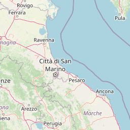
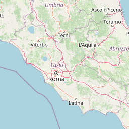
      Santa Marinella is located in Roma, Italycountry within 42° 1' 59.88" N 11° 50' 60" E (42.0333, 11.8500) coordinates. The local time in Santa Marinella is 11:36 (29.07.2025)

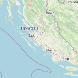
      Split is located in Splitsko-dalmatinska županija, Croatiacountry within 43° 30' 36" N 16° 26' 24" E (43.5100, 16.4400) coordinates. The local time in Split is 11:36 (29.07.2025)

      The calculated flying distance from Santa Marinella to Split is 254.13miles which is equal to 408.98 km.

      If you want to go by car, the driving driving distance between Santa Marinella and Split is 719.86 miles (1158.50 km). If you ride your car with an average speef of 112 kilometers/hour (70 miles/h), travel time will be 10 hours 21 minutes.Please check the avg.speed travel time on the right for various options

      Estimated Travel Time Between Santa Marinella and Split

      Average speedTravel Time
      30 mph (48 km/h)23 hours 60 minutes
      40 mph (64 km/h)17 hours 60 minutes
      50 mph (80 km/h)14 hours 24 minutes
      60 mph (67 km/h)11 hours 60 minutes
      70 mph (112 km/h)10 hours 17 minutes
      75 mph (120 km/h)9 hours 36 minutes

      Santa Marinella, Roma, Italy

      Related Distances from Santa Marinella

      CitiesDistance
      Santa Marinella to Rome33.92 mi (54.59 km)
      Santa Marinella to Perugia79.43 mi (127.83 km)
      Santa Marinella to Florence123.82 mi (199.27 km)
      Santa Marinella to Livorno130.84 mi (210.56 km)
      Santa Marinella to Prato133.21 mi (214.38 km)
      Santa Marinella to Naples149.42 mi (240.48 km)
      Santa Marinella to Bologna171.91 mi (276.67 km)
      Santa Marinella to Modena186.38 mi (299.95 km)
      Santa Marinella to Reggio Emilia194.12 mi (312.40 km)
      Santa Marinella to Parma205.94 mi (331.43 km)
      Santa Marinella to Genoa220.34 mi (354.61 km)
      Santa Marinella to Padova233.06 mi (375.08 km)
      Santa Marinella to Venice236.58 mi (380.75 km)
      Santa Marinella to Verona239.14 mi (384.86 km)
      Santa Marinella to Brescia255.48 mi (411.15 km)
      Santa Marinella to Bari266.72 mi (429.25 km)
      Santa Marinella to Trieste267.58 mi (430.63 km)
      Santa Marinella to Milan271.82 mi (437.45 km)
      Santa Marinella to Palermo282.21 mi (454.18 km)
      Santa Marinella to Turin296.52 mi (477.19 km)
      Santa Marinella to Cosenza297.99 mi (479.56 km)
      Santa Marinella to Taranto300.15 mi (483.05 km)
      Santa Marinella to Messina329.61 mi (530.46 km)
      Santa Marinella to Reggio di Calabria337.08 mi (542.49 km)
      Santa Marinella to Catania357.31 mi (575.04 km)

      Split, Splitsko-dalmatinska županija, Croatia

      Related Distances to Split

      CitiesDistance
      Solin to Split3.12 mi (5.03 km)
      Trogir to Split9.46 mi (15.23 km)
      Sinj to Split16.31 mi (26.24 km)
      Sibenik to Split31.57 mi (50.81 km)
      Makarska to Split33.13 mi (53.32 km)
      Zadar to Split73.49 mi (118.27 km)
      Nova Gradiska to Split128.93 mi (207.49 km)
      Slavonski Brod to Split138.46 mi (222.83 km)
      Pozega to Split139.90 mi (225.14 km)
      Zupanja to Split155.27 mi (249.88 km)
      Pula to Split159.22 mi (256.23 km)
      Rijeka to Split159.66 mi (256.95 km)
      Sesvete to Split160.90 mi (258.94 km)
      Zagreb to Split160.95 mi (259.02 km)
      Viskovo to Split164.06 mi (264.03 km)
      Bjelovar to Split166.26 mi (267.57 km)
      Vinkovci to Split169.48 mi (272.76 km)
      Pazin to Split171.96 mi (276.75 km)
      Rovinj to Split176.28 mi (283.70 km)
      Vukovar to Split179.01 mi (288.09 km)
      Novi Marof to Split183.63 mi (295.53 km)
      Krapina to Split185.21 mi (298.07 km)
      Ivanec to Split188.32 mi (303.07 km)
      Varazdin to Split193.39 mi (311.24 km)
      Umag to Split196.02 mi (315.46 km)